In 1962, a talented, unique and now legendary woman began publishing mimeographed copies of her notes about traveling on the Mississippi River above Dubuque, Iowa.
Now, 60 years later, we pay tribute to Mildred Quimby, whose original Harbor Guide has brought us to this year’s edition of Quimby’s Cruising Guide that now covers 9,436 miles on 7 major inland waterways and lists information about 754 points of interest to cruising boaters.
Mildred was a college educated journalist who worked at various publications and a federal agency in Washington, D.C. before returning to her roots around Prairie du Chien, Wisconsin.
She was described as “a character in every sense of the word, a river rat to be sure…” with the term used in its very best sense.
She accumulated her material by either traveling on the river in her 16-foot boat or by car. She realized people were curious about her notes so decided to publish them as a guide, complete with hand-drawn pictures along with miscellaneous river information.
Fittingly, after her death in 1983, her ashes were cast into her beloved Mississippi River.
While some of her guides were lost in a fire, we have been able to collect many of them and by adding copies from when we began publishing the guide, can chronicle the growth of what has frequently been referred to as “the bible” for boaters traveling the inland waterways.
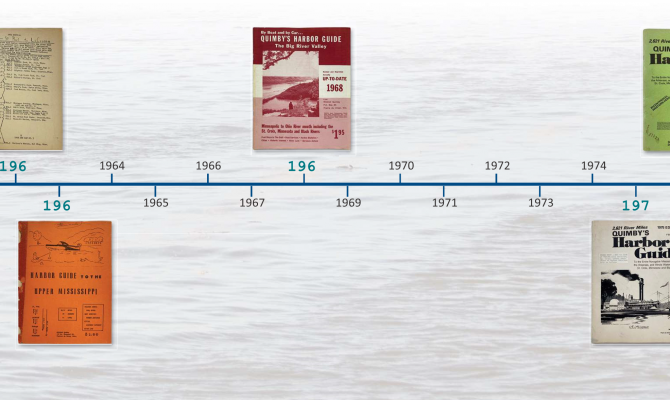
In 1963, The Harbor Guide to the Upper Mississippi included the St. Croix and Minnesota Rivers for a total of 367.9 miles, 78 harbors and 13 locks. With hand drawn pictures on the cover, the mimeographed edition had drawings of harbors, where to go for boat services, items of historic interest and a variety of river lore and quotes. The main article was “The Modern Mississippi and its Past.” All that cost $1.00
Her 1965 edition contained much of the same information along with mileage charts, locations of fuel stops and still cost $1.00.
The 1968 edition’s cover had a photo and was printed in red ink. Coverage expanded down the Mississippi to the mouth of the Ohio River and also the Black River. For $1.95, her guide boasted of being “revised and reported annually.”
By 1975, 2,621 miles were covered on the entire navigable Mississippi, Illinois Waterway and the Arkansas, St. Croix, and Minnesota Rivers. VHF-FM call stations were listed by mile number and their call letters. Purchase price was $3.00 direct or $3.50 by mail and now ads appeared.
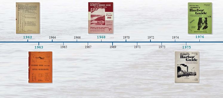 There were more ads in 1976 and an article on a Western Hero, George Rogers Clark.
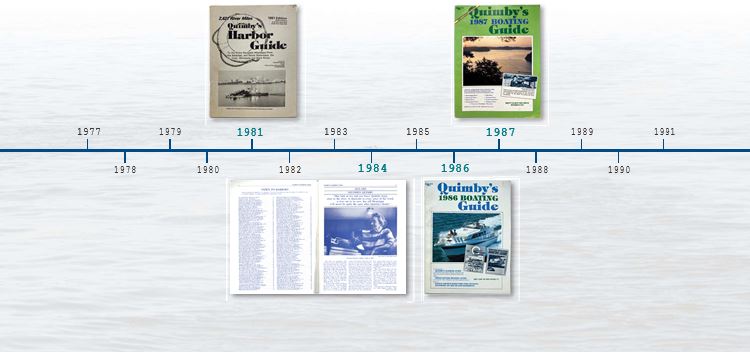
The cover of the 1980 edition, now printed and stiffened, had a picture of President and Mrs. Carter on the DELTA QUEEN when they cruised from St. Paul to St. Louis. Mildred’s drawings still appeared on the inside pages.
The main article for 1981 was about Higgins Eye mussels and the possibility of prohibiting some dredging to protect their critical habitat. VHF-FM channel allocations were listed. New pricing was $6.00 at harbors, $7.37 for first class mailing and $6.92 for third class.
1982 added information on the Atchafalaya Tributaries in Louisiana and the Wisconsin River.
The 1983 feature article detailed three stretches of the Upper Mississippi Wildlife and Fish Refuge. Over 100 harbors were listed including 22 on the Lower Mississippi. The first class mailing price dropped to $7.22.
The 1984 edition was a memorial issue dedicated to Mildred Quimby, 1913-1983 and highlighted her life. The guide was “totally revised” by the new publisher, The Waterways Journal.
The Tennessee River and Tennessee Tombigbee Waterway were added in 1985. The $6.95 guide had a comprehensive article on locking through and for greater durability, the cover was stiffened again.
A big change in 1986 was combining with the Three Rivers Boating Guide to become Quimby’s Boating Guide. By adding the Ohio, Allegheny and Monongahela Rivers, it became the “single source directory for cruising anywhere on the Inland Waterways.” A trip planner and log were added as well as an index to advertisers. All this was now in color.
The Cumberland River was added in 1987 with an article on its hospitality. Now covering 5, 763 miles, the featured article was by John Hartford, river pilot and composer of “Gentle on My Mind” made popular by Glen Campbell.
1988 was the first of an ongoing quest for more sturdy binding by adding twin spiral bindings. There was a boat trip report from Kentucky Dam Marina to Florida by Country Hall of Famer and avid boater Eddie Arnold on his 53′ Hatteras, the SALLY K. Proving he really was a boater, he recounted bending a prop at Columbus, Mississippi.
The binding was switched in 1989 to smaller, single spirals, there were more sources of information, descriptive articles on the basics of river boating and how to lock through. 6,107 miles were covered for $10.95.
Changes in 1990 included coverage of the Black Warrior, Apalachicola and Chattahoochee Rivers and the Flint River System. Author David Ross cruised those waterways in his 1955, 21′ Lone Star Cruiser.
Now up to 6,870 miles in the 1991 edition, the Kanawha River was added. There was also an article on river people, Captain Peanuts and the Fat Lady Pie.
At $10.95 in 1992, or $12.45 by mail, the 196 page edition had a feature on where to rent houseboats.
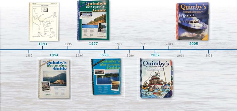
The 1993 edition had a new services directory of where to stay, eat, sleep and buy provisions along with phone numbers of chambers of commerce and locks. The Tall Stacks Festival in Cincinnati was featured and so was a caution against using outdated copies. Complaints about faulty information were frequently traced to using such data which highlighted how fast things changed.
There was a price increase in 1994 to $12.95 but with an extensive article on the Great Flood of 1993 that produced record high water levels for extended times.
The Missouri River was added in 1995 with an article titled “Alleged Tiger is a Pussycat,” and mileage was increased to 7,544. A significant improvement was the addition of Jerry Troyanek who started as a cruising representative on the Upper Mississippi and Illinois Waterways in his 36′ houseboat, DAWN TREADER III. He displayed a Quimby’s Cruising Guide banner on his upper deck rails. He originally signed up to cover 6,810 miles but in the next four years, covered far more than that.
 In 1996, Troyanek covered the Cumberland, Tennessee and Ohio Rivers and added side trips to the Monongahela, Allegheny and Kanawha Rivers. The price was $15.95 and included a profile of the United States Coast Guard buoy tender WYACONDA and the work it performed.
David Ross was back in 1997, now in a 22′ C-Dory, with a round trip run from Greenville, Mississippi to Tulsa, Oklahoma on the Arkansas River System.
A major addition in 1998 was coverage of the Gulf Intracoastal Waterway East (GIWW) from Mobile, Alabama to Carrabelle, Florida, detailing a route cruisers could follow without going on open water. Cliff Conrad provided the details.
The GIWW West was added in 1999, bringing total mile coverage to 8,619. David Ross reported on Louisiana’s “other” waterways, the Red and Quachita Rivers and a piece on river birds was included.
Now priced at $25.00, the guide offered 9,301 miles of coverage of 21 waterways on 274 pages for 2000. 50 marinas were added with a Conrad travelogue from New Orleans to Galveston, Texas with some interesting side trips.
A 2001 profile of the Atchafalaya River revealed 133 miles of one of the largest, relatively unspoiled wetland regions of the U.S. but also revealed significant current, no locks and dams and facilities for boaters only at Morgan City. There was also information about river critters. Continuing the quest for durability, the spiral ring size was increased.
2002 saw the addition of 32 tabs to make it easier to find information.
Those tabs were then reinforced in 2003. A marina rating system was implemented using an elaborate 100 point grading system. On-site inspectors on various waterways used this and only a few places received the highest 5 anchor rating. The lead article profiled distinctive bridges.
With 40 percent of readers indicating fishing was a secondary activity, the 2004 edition’s article featured river fishes. It also had an article about the bicentennial re-enactment of the Lewis and Clark Expedition with artwork by river artist Gary Lucy. And 12 smaller but thicker binding rings appeared.
The 2005 edition, now $39.00, had an article about the wide variety of Boats of the Waterways and a mention about this author cruising the Upper Mississippi rating marinas and using his inflatable boat named the MILDRED Q. to help accomplish that task.
A new series began in 2006 featuring places of interest along the eight major waterways where the water could be seen from the facility. This year’s topic was Bed and Breakfasts. Dock fees were listed as either above or below $1.00 a foot. And due to hurricanes in 2005, boaters on the GIWW and Tenn-Tom were urged to contact places directly due to the major damage and re-building.
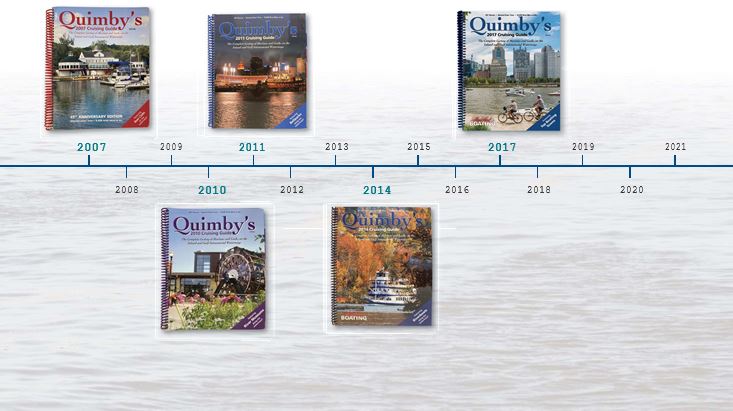
The 2007 topic was Boat Clubs. Also explained was what qualified a marina for a 5 star rating. Only 21 out of 543 marinas on 10 different waterways earned that honor.
To help cruisers stretch their legs, hiking and biking trails were examined in 2008. Gas was $3.00 a gallon so on-site inspections ceased.
In 2009, restaurants were highlighted. But while an unsettled economy was playing havoc in the country, some folks just decided to follow Erma Bombeck’s advice: “Seize the moment! Remember the women on the Titanic who waved off the dessert cart.” More seriously, the anchor ratings were discontinued.
 One inclusion in the 2011 article about sports stadiums was Wrigley Field in Chicago that qualified because Lake Michigan could be seen from the Upper Deck. An interesting piece of Wrigley’s history was that in one game there in 1917, both the Chicago and Cincinnati pitchers had no-hitters through 9 innings. Cincy had a hit in the 10th and scored then hurler Fred Toney completed his no-hitter for the win.In 2010, river museums, dubbed “History’s Attics” were profiled to honor our waterways’ heritage.
2012 was the 50th anniversary of the origin version. Golf courses were the featured focus and sprinkled with facts like more than half the golfers shoot over 100 and the odds of a hole in one are 1 in 18,606. Also noted was that golf’s financial impact was around $75 billion a year while boating’s was about $30 billion. Who said boating was a rich man’s sport?
One highlight from the 2013 article on River Festivals was that at Dog Days in Stockholm, Wisconsin, an award was given to the owner who looks most like his dog. Another was the Great River Tug Fest between LeClaire, Iowa and Port Byron, Illinois ACROSS the Mississippi River using a 2,700 foot, 680 pound rope. Then there was the Redneck Fishing Tournament on the Illinois where teams compete to see who can land more jumping Asian Carp in their boats – no nets allowed and helmets are recommended.
Sandy Steele wrote about Riverboats in 2014, describing over 30 of these classics. The guide was a sponsor of the Centennial Riverboat Festival in Louisville. Revised section introductions with navigation notes specific to that area were included toward the goal to provide the most accurate, accessible information available.
The 2015 edition began a series of six articles titled “Lovin’ the Loop.” Taken from information supplied by Loopers, it had information, suggestions and bits and pieces about all things Looping. The series continued on the website.
2016 oversaw 1,250 listings and an article on great boating lakes.
The price was $35.00 in 2017 and the 55th edition featured river towns.
2018 had a listing of 24 Top Boating Bars with a strong advisory to not drink and boat. A new website was added along with a monthly email letter.
There were descriptions of many top marina restaurants in 2019. A description was included how the guide uses email questionnaires and then follows up with more email and phone calls to verify information. The website was expanded and a request to follow them on Facebook was included.
In 2020, the guide included an article about seven town tours on the Western Rivers. The guide now covered 9,436 miles.
Dr. John E. Gunning wrote about a Trailerable Cruise in America’s Heartland in 2021. It covered a 1,043 mile route from the Tennessee River to the Ohio and up the Cumberland to the head of navigation. It was designed to take about two weeks.
And that brings us to the question, what’s ahead in 2023 for this long-trusted cruising guide?