The Army Corps of Engineers has posted mile markers each statute mile starting with Mile 0 at the Harvey Lock in New Orleans and increasing until the Mexican border. Navigational markers run clockwise around the coast, so moving westward, keep red markers on your starboard side and green to port. Confusion can occur where the GIWW intersects with other channels. You can distinguish which markers designate the GIWW by looking for a yellow square beneath the number on markers to be kept on your port side and yellow triangles beneath the number on markers to leave to your starboard side.
The Corps is charged with maintaining the waterway with a controlling depth of 12 feet, but due to normal sedimentation and storm-related erosion issues, some stretches may be as low as 10 feet, with shoaling near inlets causing shallower spots. While this is primarily a concern for commercial barges forced to operate with lighter loads, it is good practice to check for Coast Guard notices to mariners for any current problem areas. A perennial problem area is near Rollover Pass adjacent to Bolivar Peninsula.
Half a mile west of the point where the Harvey Canal converges with the Algiers Canal (an alternative route to the Mississippi), boaters pass through the GIWW Westbank Closure Complex, a 225-foot navigable floodgate combined with the world’s largest pump station and an earthen levee all to help prevent flooding of the type experienced during Hurricane Katrina.
Locks at Algiers, Harvey and Port Allen transport vessels from the level of the GIWW to that of the Mississippi. Other locks in Louisiana were built to prevent intrusion of saltwater into the waterway and freshwater reservoirs. Locks were built where the waterway crosses the Colorado River in the 1950s. Traffic can be delayed for several days if the river is in flood.
The Laguna Madre reach from Corpus Christi to Brownsville spans a fragile ecosystem averaging 2 to 3 feet in depth except for the 9 to 10 foot depth in the waterway. Aside from providing a coastal transportation route, this segment is a favorite destination for speckled trout fishermen.
In Louisiana, shipping crosses the GIWW en route to and from Lake Charles. Major shipping routes intersect with the GIWW in Texas, serving Orange, Beaumont, Port Arthur, Freeport, Port Lavaca/Calhoun, Corpus Christi and Port Isabel/Harlingen.
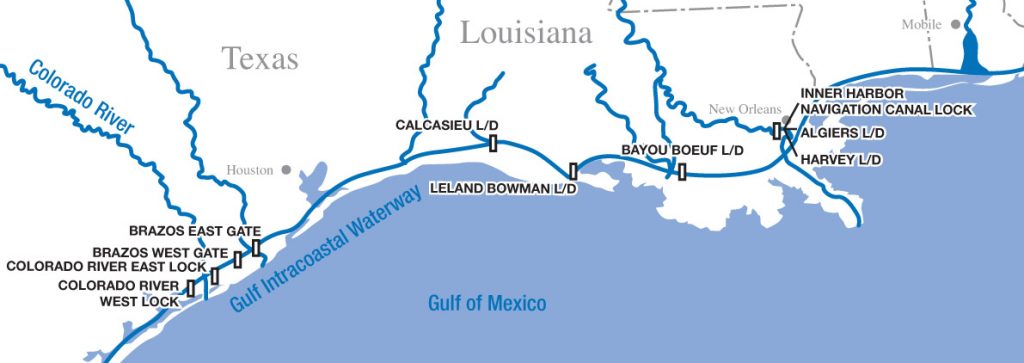
GIWW West Lock Mile Markers
Harvey Lock: 0.0
Algiers Lock: 0.0
Bayou Boeuf Lock: 93.3
Leland Bowman Lock: 162.7
Calcasieu Lock: 238.5